


© Jon Sharpe, 2013
(Continued from Part 3 of this series, History of the Elwha River Dams)
A river carries cobbles, gravel, silt and logs along its length. These materials build the riverbed, side channels and gravel bars, providing fish and animal habitat. A river is in constant motion.
The Elwha River dams interfered with the river's lifecycle, blocking the natural flow of materials from the mountains to the Strait of Juan de Fuca. Lacking replenishing sediment, habitat degraded in the 5-mile stretch of river between the Elwha Dam and the Strait. Salmon runs declined precipitously. As sand disappeared from the beach, so did the clams and the swimming holes. The Strait chewed back the shoreline and since 1939, 22 acres of land has been lost to coastal erosion at the river delta. On the reservation, coastal erosion ranged from 125' to 500' of shoreline. Ediz Hook, a spit that shelters Port Angeles Harbor, created from sand carried by the Elwha, eroded from lack of river sediment and been artificially maintained by the US Army Corps of Engineers since 1974.
Before the Elwha River restoration began, 24 million cubic yards of sediment - silt, cobble, sand, gravel, and boulders - was trapped behind the two dams. It was enough to fill 8 Safeco Fields to the top of the roof. It would be by far the largest volume of sediment ever released in a dam removal project. How to manage a controlled release of sediment was the biggest challenge of the Elwha restoration.
An Environmental Impact Assessment estimated it would cost $22 million to dredge and slurry the sediment to the Strait. This was not practical; the river would have to carry the sediment. But it had to happen gradually, to prevent the river from digging through the soft mud and leaving a moonscape of unnatural, dangerous cliffs. Scientists wanted the river to meander through the sediment on the reservoir lake beds, sluicing it like a fire hose, and shaping the river in stepped-down terraces. To do this, the river had to be lowered gradually, by first by emptying the reservoirs, then removing the dams from the top, a few feet at a time.
In July 2011, the reservoirs behind both dams were drawn down. The Elwha Dam, closer to the river mouth, was removed first, beginning in September, 2011. The water level was allowed to drop gradually as the spillways, penstocks (pipes that carried water to the powerhouse), and powerhouse were removed. 200,000 cubic yards of fill was removed from behind the dam to excavate the original river channel.
The taller, narrower Glines Canyon Dam was removed by lowering Lake Mills by 17 feet, to the bottom of the spill gates, then removing the first 17 feet of the dam to the new water level. Dam removal continued by taking out notches on alternating sides of the dam and gradually lowering the water level. The headgate house, penstock, and powerhouse were removed. The spillway and a massive concrete block called the thrust block will remain as viewing platforms for the restoration project. The project will be stopped for up to 6 months of the year to protect migrating fish in the lower river. Scientists built the models for restoring the river, but would nature do what scientists expected?
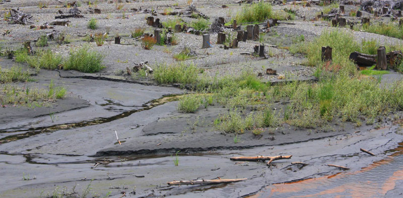
The Elwha sluices sediment as it finds a new channel on the lakebed of former Lake Aldwell. Iron is precipitating in red streaks on the riverbank as it is exposed to air.
As predicted, the sediment has been the biggest challenge of the restoration so far. In April 2013, nearly 200,000 chinook smolts were released from the state fish hatchery. The morning after the release, hundreds of dead smolts were found at the river mouth and sandbars, their gills clogged with sediment. The turbidity or amount of sediment in the water had doubled shortly after the fish were released. The salmon suffocated. The habitat manager for the Lower Elwha Klallam Tribe said he thought few of the smolts made it into the Strait. The Clallam County Fish and Wildlife biologist said, "We'll try not to make the same mistake." The hatchery planned to release 900,000 juvenile salmon in June. I expect they did since the rearing pens were empty when I visited.
Also in April, with two-thirds of the Glines Canyon Dam removed, the sediment overwhelmed the new Elwha Water Facilities Project, built by the Department of the Interior for the city of Port Angeles in 2011. Removal of the final section of the upper dam is on hold until the Water Facility is fixed, and most likely until next spring after the fish migration. It's estimated that the river has carried just 18% of the sediment downstream so far. Most of it is waiting behind the last 60 feet of the Glines Canyon Dam.

The Elwha carries glacial flour as it flows into the former Lake Mills. Lake Mills was as deep as the treeline.
I began my river tour at its muddy mouth, so it was striking to see the glacial, teal color of the Elwha at the south end of former Lake Mills. That stretch of river was always beyond the reach of the dams. Where it traverses the lakebeds and dam sites, the river is brown with sediment. That sediment is depositing gradually along 13 miles of the river, from Lake Mills to the beach. The habitat is recovering. Where the Elwha meets the Strait, the rocky beach is covered with sand and a sandbar splits the river as it pours into the Strait. Just a few weeks ago, the sandbar wasn't even there. All this change, from just 18% of the sediment.
Next in Part 5 of this Story: It's About the Salmon - The Lower Elwha Klallam Tribe
-- Marilyn Hair
Sources:
Mapes, Lynda. Elwha A River Reborn. Seattle: The Mountaineers Books, 2013.